Introduction: The "environmental sentinel" of precision agriculture era"
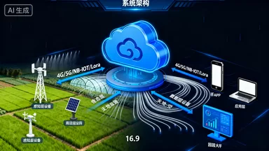
in the wave of digital agriculture transformation, meteorological environment monitoring system has become a core component of modern agricultural infrastructure. The system seamlessly connects the micro environment of farmland with macro meteorological data through Internet of Things technology, and constructs a multidimensional perception network covering "sky earth space". Compared with traditional manual observation, the automated monitoring system has achieved a leap in data granularity from the hour level to the second level, providing a high-quality data base for smart agriculture applications such as disease and pest warning, precision irrigation, and crop model optimization. Firstly, the system architecture is layered and analyzed
the three-layer architecture design concept
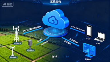
1.1 the system strictly follows the Internet of Things standard architecture, which is divided into perception layer, transmission layer, and application layer
perception layerIt is deployed in the field and consists of multi-functional weather stations, various sensor nodes and edge computing units. The weather station is equipped with a built-in main control chip, responsible for protocol conversion and data preprocessing, and supports:
Bus mounting up toMultiple sensors form a distributed collection network.RS485Transport layer32Adopting a dual-mode redundancy design of "wired+wireless". Wireless side support
Full network (7 modesfrequency)4G/5GNarrowband Internet of Things and14Ethernet andNB-IoTAccess. The system intelligently switches the optimal communication path to ensure reliable data transmissionLoRaWANLow power wide area network; Standard provided on the wired sideRJ45Above.2.4GHz WiFiApplication layer99.5%Relying on cloud computing platforms to achieve data storage, analysis, and visualization. The platform adopts a microservice architecture and supports
Concurrent access of 10000 level devices, with data response latency lower thanMilliseconds.102、 Core equipment composition and technical specifications100Multi element meteorological station host
The meteorological station adopts
2.1 Waterproof grade chassis, built-in industrial grade
Processor, runningIP67Embedded systems. The core functions include:ARM Cortex-A7Data collection frequencyLinuxAdjustable, default upload of packaged data once every minute
- Storage capacity: 1Hz~0.1Hz: Built in
- , supports offline storageTian Data8GB eMMCExpansion interface30: 4 routes
- 2 routesInput, 1 channelRS485Working temperature range4-20mAAdapt to extreme weather conditionsModbus TCP
- Sensor matrix configuration: -40℃~+85℃The system supports modular sensor selection, typical configuration scheme:
2.2 Atmospheric Environment Group
Integrated temperature and humidity sensor (Switzerland
chip): temperature accuracy:
- , humiditySensirionAtmospheric pressure sensor (pressure resistance type): range±0.2℃@-10~50℃Resolution±2%RH
- Illuminance sensor (cosine correction): spectral range300-1100hPa, range0.1hPa
- UV sensor: measurement400-700nmBand,0-200000Lux
- Meteorological Dynamics GroupUV-A/BWind speed sensor (ultrasonic or mechanical): start wind speed0-15mW/cm²
Wind resistance capability:
- Wind direction sensor (magneto electric):0.1m/sDirectional resolution, no dead zone design75m/s
- Rain sensor (tipping bucket type): resolution16Dou, accuracy
- Air Quality Group0.2mm/Dou, accuracy±2%
Air Quality Group:
- PM2.5/PM10Sensor (laser scattering method): minimum measurable particle size0.3μmLifespan>3Year
- CO₂Sensor (non dispersive infrared): rangeNDIRAccuracy0-5000ppmNegative oxygen ion detector (capacitive): range±50ppm
- One0-50000, resolution 1/cm³Soil moisture group
Soil temperature sensor (:
- , accuracyPT1000) : -20~80℃soil moisture sensor (±0.5℃
- frequency domain reflection):FDRAccuracy0-100%VWCSoil±3%
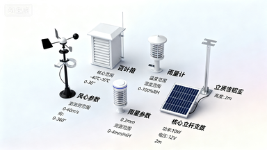
- Value sensor: rangepHAccuracy3-10pH(Optional)±0.1pH[Image generation suggestions] Create a product display image of "Sensor Family Photo" from a top-down perspective Angle arrangement, including anemometer, louver box, rain gauge, solar panel, pole bracket, etc. Each component is labeled with a name and core parameters, with a transparent or light gradient background.453、 Deep analysis of communication technology
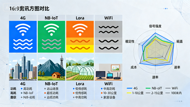
Multi mode adaptive communication strategy
3.1 The system has a built-in intelligent routing algorithm and prioritizes selecting low-power mode:
pattern
- 4G Cat.1Daily data transmission, power consumptionpattern<100mA
- NB-IoTWeak signal scenarios such as basements and mountainous areas, with strong penetration abilitypattern
- LoRaSelf built LAN with single gateway coverageKilometer farmland5-10Ethernet mode
- Facility agriculture greenhouse, stable and reliableData encryption and security mechanisms
3.2 The transport layer adopts
- Encryption protocol to prevent data hijackingTLS 1.3Device access requires bidirectional certificate authentication
- support
- Private network access to meet the needs of confidential unitsVPN4、 Cloud platform function matrix
Data visualization engine
4.1 The platform provides three ways to present data:
Real time monitoring
- 3-second refresh curve, supporting multi device screen comparisonHistorical retrospective
- 1-minute granularity data query, scalable timelineReport Center
- Automatically generate daily, weekly, and monthly reports, supportedExportPDF/ExcelIntelligent alarm system
4.2 Support the five level warning mechanism:
Threshold triggering
- Single parameter over limit alarm (such as temperaturecombination conditions>35℃)
- multi parameter logic judgment (such as humidityand temperature>80%trend warning<15℃)
- abnormal rate of change (such as pressure drop within 1 hourequipment offline)>5hPa)
- Device OfflineHeartbeat packet loss exceeds15minute
- Manual inspectionCustom timed reminders
Alarm push channel:APPPop up window, WeChat official account, SMS, voice phoneWebhookInterface docking with enterprise WeChat/DingTalk.
4.3 Configurational configuration
Users can customize:
- Equipment naming conventionsSupport batch import of device names
- Range mapping: 4-20mANonlinear transformation of corresponding physical quantities
- Formula calculationDerivative indicators such as dew point temperature, saturated vapor pressure, etc
- Scene modeOne click switching of threshold schemes for parameters such as "seedling period", "flowering period", "harvesting period", etc
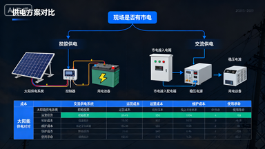
5、 Guidelines for selecting power supply system solutions
5.1 Communication power supply plan
Applicable scenariosFacility agricultural greenhouses, park management stations, and farmland with access to municipal electricity
Configuration checklist:
- AC220VTurnDC12VVoltage stabilizing power supply (optional)5A/10APower lightning arrester (nominal discharge current
- armored cable, buried depth20kA)
- 1.5mm²meters≥0.7distribution box
- protection levelIP65advantages
low cost, simple maintenance, no endurance anxietydisadvantages
large wiring engineering volume, lightning risk, grid fluctuation impactsolar power supply scheme
5.2 configuration parameters
solar panel:
- monocrystalline siliconconversion efficiency50W/18Vlifespan>18%years>20battery
- lithium iron phosphatecycle life12V/40AHtimes, working temperature>2000controller-20~60℃
- type, charging efficiency: MPPTwith battery>95%managementBMSendurance design
- can work for 7 days on continuous rainy days (calculated based on daily power consumption)Installation specifications20WhTilt angle of solar panel=local latitude
(Winter optimization):
- Facing due south with no obstructions+15°Installation height of pole
- Rice, to prevent shading
- 6、 Installation and deployment implementation guide>3Site selection principle
6、 Installation and Deployment Implementation Guide
6.1 Site selection principle
- OpennessSurrounding wind speed and direction sensors10There is no building obstruction within the meter
- RepresentativenessMonitor typical plots in the monitoring area to avoid local microclimate interference
- SecurityStay away from high voltage lines and areas prone to water accumulation, and take appropriate anti-theft measures
- Communication testingBefore installation, on-site testing of signal strength is required (RSRP>-105dBm)
6.2 pole installation specifications
standard poles (2.5meters/3.5meters optional):
- Foundation excavation40×40×50cmConcrete foundation
- Pre embeddedM16Foundation bolts, horizontal deviation<2°
- Rectify the verticality of the pole and fix it with grouting
- Installation sequence of sensors (bottom-up): soil sensors→Loubet box→Rain gauge→Solar panels→Wind speed and direction indicator
Simple tripod:
- Suitable for temporary monitoring and scientific research experiments
- Rapid deployment time<30minute
- Need to balance weight30kgAbove or fixed with ground nails
6.3 LEDDisplay screen deployment
Technical specifications:
- Dot matrix size:P10 (10mmDistance), semi outdoor/full outdoor appearance
- Power consumption: average100W/m²Peak value300W/m²
- Perspective: Horizontal>120°Vertical>60°
- Brightness:>5000cd/m²Automatic light sensing adjustment
Display content arrangement:
第一行:监测点名称(滚动显示)
第二行:温度 25.6℃ | 湿度 68%
第三行:PM2.5 35μg/m³ | 负氧离子 1800个/cm³
第四行:更新时间 12-16 14:30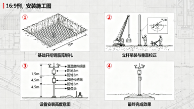
7、 Data management and analysis strategies
7.1 Data quality control
The system has a built-in three-level data cleaning mechanism:
- Physical boundary filteringExclude outliers that exceed the specified range
- Continuity testingTime series mutation detection (such as temperature changes within 1 minute>5℃)
- multi-source cross validationsuch as using the correlation between atmospheric humidity and soil humidity to assist in judgment
data validity target: (annual statistics)>98%Typical agricultural application model
7.2 Disease and pest warning model
Cucumber downy mildew: temperature:
- Humidity15-22℃ + Leaves are moist>85% + Hour>6Aphid outbreak: temperature
- Humidity20-28℃ + wind speed<60% + wind speed<3m/s
Irrigation decision model:
- Lower threshold of soil moisture: field water holding capacity60%
- Evapotranspiration calculation:Penman-MonteithFormula, requires input of temperature, humidity, wind speed, and radiation data
Frost warning model:
- Warning conditions: temperature<2℃ + Wind speed<2m/s + Clear sky radiation (cloud cover<20%)
- advance amount: hours2-48. Operation and maintenance management and maintenance standards

daily inspection checklist
8.1 cycle
| inspection items | standards | tools | daily |
|---|---|---|---|
| platform data online status | online | 100%mobile phone | weeklyAPP |
| solar panel cleanliness | no dust or bird droppings on the surface | soft cloth, cleaning agent | monthly |
| rain gauge bucket cleaning | no debris blockage | screwdriver, water | quarterly |
| sensor accuracy verification | error | nominal value 2 times<standard | annual |
| battery capacity testing | capacity | nominal>internal resistance tester80% | common fault troubleshooting |
8.2 phenomenon
temperature data constantpossible cause: loose sensor wiring0℃
- address conflictRS485troubleshooting steps: inspection
- line voltage (normalA/B) Rescan the device address2-3VPhenomenon
The device frequently goes offlinePossible reasons:
- Card arrears, poor antenna contact, low power supply voltageSIMTroubleshooting steps: Check signal strength, measure battery voltage (
- ), replace antenna position>11.5VPhenomenon
The rainfall data is abnormally largePossible reasons: Insects entering the tipping bucket, interference from bracket vibration
- Solution: Install insect proof nets and reinforce pole foundations
- 9、 Typical application scenario cases

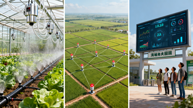
Facility agriculture greenhouse monitoring
9.1 Project background
Planting tomatoes in a multi acre greenhouse: 100Planting tomatoes in a multi acre greenhouse
Configuration plan:
- Every20Deploy one set of standard meteorological stations per mu
- IncreaseCO₂Sensors (promoting photosynthesis)
- Soil moisture sensors are deployed at 5 points (four corners+center)
- useAC220VPower supply+UPSspare
Application effectiveness:
- The incidence of diseases has decreased40%(Accurate warning)
- Water conservation30%(on-demand irrigation)
- Increase production15%(Environmental optimization)
9.2 Field crop monitoring network
Project background: 5000Mu wheat planting base
Configuration plan:
- Grid deployment, every200One monitoring point per mu
- Solar power supply system
- NB-IoTCommunication (low power consumption and wide coverage)
- Key monitoring of rainfall, soil moisture, and wind speed
Application effectiveness:
- Improved precision of irrigation timing50%
- Early risk of lodging48Hourly warning
- Meteorological data supports agricultural insurance claims
9.3 Modern Agricultural Industrial Park
Project backgroundA comprehensive park integrating planting, sightseeing, and scientific research
Configuration plan:
- Main entrance settingLEDLarge screen (3m×2m), real-time display of environmental data
- The scientific research area is equipped with high-precision sensors (temperature±0.1℃)
- linked ventilation, wet curtains, supplementary lighting and other equipment to achieve automated control
10. Development trends and technological prospects
10.1 technological evolution direction
integrated sensingintegrated multispectral imaging, laser radar (LiDAR) three-dimensional environmental monitoring to achieve synchronous monitoring of crop growth and environment.
Edge intelligenceDeploying lightweight technology at the meteorological station endAIModel to achieve edge recognition of pests and diseases, reducing cloud dependence.
Digital twinBuild a 3D digital model of farmland, map the physical environment in real-time, and support virtual simulation experiments.
Blockchain certificationMeteorological data is stored on the blockchain to ensure its immutability, serving the traceability of agricultural products and carbon trading.
10.2 Standards and specifications
- Following the "Agricultural Meteorological Observation Standards", meeting the technical requirements of the "Internet of Things Meteorological Data Collector", and supporting the identification system of the agricultural Internet of Things, the agricultural meteorological environment monitoring system has evolved from a single data collection tool to a "nerve endings" for agricultural production management. Its value lies not only in real-time data, but also in the long-term accumulation of climate resource databases to support macro decisions such as agricultural zoning, variety selection, and disaster assessment. In the future, as equipment costs continue to decrease and analysis capabilities increase, each farmland will have its own "environmental identity card", truly realizing the vision of precision agriculture of "adapting to the weather and fertilizing according to the soil". Deployment suggestions: It is recommended to use "solar energy" for new projectsQX/T 45-2007)
- Meets the technical requirements of IoT meteorological data collectors(GB/T 33703-2017)
- Support the identification system of agricultural Internet of Things(Ecode)
Conclusion: Building a sustainable agricultural data ecosystem
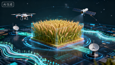
The agricultural meteorological environment monitoring system has evolved from a single data collection tool to the "nerve endings" of agricultural production management. Its value lies not only in real-time data, but also in the climate resource database formed through long-term accumulation, which supports macro decisions such as agricultural zoning, variety selection, and disaster assessment. In the future, as equipment costs continue to decline andAIEnhanced analytical ability, each farmland will have its own "environmental identity card", truly realizing the vision of precision agriculture of "adapting to the weather and fertilizing according to the soil".
Deployment suggestionsSuggest using "solar energy" for new projects+4G"Standard configuration, priority should be given to upgrading existing facilities, and the data platform should be openAPIInterface, easy to connect withERPDocking with traceability systems to maximize the value of data assets.


Leave a Reply